
Engineering Roads Around Real Field Evidence
Highway widening projects, interchange upgrades, and new arterial corridors across the UAE all share one engineering principle: a road built on assumptions fails faster than one built on measured demand. Pavement thickness, drainage capacity, lane configuration, and shoulder width are all specified against the loading a corridor will actually carry, which makes field-verified traffic data a core engineering input rather than a formality.
Road authorities commissioning rehabilitation or expansion works increasingly require a current traffic dataset before approving a design package, since outdated counts can lead engineers to under-specify pavement structure or misjudge the service life a new asset needs to deliver.
Design-and-build contractors working on UAE road packages have also learned that revalidating traffic assumptions mid-project, after a scope change or a nearby development comes online, is far cheaper than discovering a capacity shortfall after the asphalt has been laid.
Automated Traffic Counts (ATC) for Pavement and Capacity Design
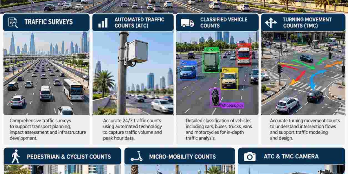
Pavement engineers size a road's structural layers around cumulative axle loading over its design life, and that calculation begins with Automated Traffic Counts (ATC) gathered continuously at the corridor level. Unlike short manual tallies, ATC sensors log every vehicle around the clock for days at a stretch, producing the volume and loading profile that pavement design software and capacity models both depend on.
This continuous dataset also exposes the directional imbalance common on commuter corridors, information that directly shapes decisions on reversible lanes, additional through-lanes, or auxiliary turning lanes at upcoming junctions.
Peak-hour and off-peak patterns captured through continuous ATC deployment also help traffic engineers set realistic design-hour volumes, which is the single number that most heavily influences how many lanes a new or widened road segment is ultimately built with.
Classified Vehicle Counts and Structural Design Decisions
A road carrying a heavy share of trucks and buses needs a fundamentally different structural cross-section than one dominated by passenger cars, and Classified Vehicle Counts are what tells engineers which scenario they are actually designing for. By splitting traffic into categories such as light vehicles, buses, and multi-axle trucks, this data feeds directly into pavement thickness calculations, bridge loading assumptions, and maintenance scheduling.
Industrial routes feeding ports, logistics zones, and construction corridors in particular rely on accurate classification, since underestimating the heavy-vehicle share here shortens pavement life far faster than on a typical residential collector road.
Classification data collected at bridge approaches and weigh-sensitive sections also informs structural load rating reviews, helping asset owners decide whether an aging bridge or culvert needs reinforcement before heavier traffic is allowed to continue using it.
Turning Movement Counts (TMC) for Junction and Interchange Design
Every signalized junction or roundabout upgrade on a UAE road improvement project is designed around a very specific question: how many vehicles turn which way, and when. Turning Movement Counts (TMC) answer that question directly, recording approach-by-approach movement volumes that feed signal phasing plans, lane-use designs, and roundabout capacity checks.
Road agencies use this data to decide whether an at-grade junction can be optimized with better signal timing or whether the long-term solution is a grade-separated interchange, a decision with major cost implications that should never rest on outdated or incomplete movement counts.
Turning movement data gathered across multiple junctions along a corridor also allows engineers to model signal coordination as a network rather than junction by junction, which is often the difference between a road that flows smoothly during peak hours and one that backs up at every intersection.
Designing Safer Corridors for Pedestrians, Cyclists, and Light Vehicles
Road safety audits across the UAE now weigh non-motorized movement as heavily as vehicle throughput, which is why Pedestrian & Cyclist Counts have become a standard input on urban road improvement schemes. Recording how many people cross at specific points, use existing crossings, or ride along a corridor gives safety engineers the evidence needed to justify raised crossings, refuge islands, or dedicated cycle tracks.
Alongside these counts, Micro-Mobility counts capture how e-scooters and other light electric vehicles are using the same corridors, a travel pattern that barely existed a few years ago but now shapes lane-width decisions and barrier placement on many newly resurfaced roads.
School zones and community roads in particular benefit from dedicated non-motorized counts, since the right mix of signage, raised crossings, and speed-calming measures depends on knowing exactly where and when pedestrian activity peaks along a given stretch of road.
Camera-Verified Data for Infrastructure-Grade Accuracy
Infrastructure decisions carry long design lives and significant construction budgets, so road authorities expect survey data that can be checked, not just trusted on faith. An ATC & TMC Camera setup provides exactly that assurance, recording continuous footage alongside the automated counts so any classification or turning movement can be verified against a time-stamped clip during design review.
This verifiable layer matters most on contested design decisions, such as whether a junction truly needs a dedicated right-turn lane or whether a corridor's truck share justifies a heavier pavement specification, where reviewers want evidence they can independently confirm rather than a summarized number alone.
Camera verification also protects infrastructure budgets on contested value-engineering reviews, where a contractor proposing a cheaper, narrower cross-section needs to be measured against the same verifiable baseline the original design relied on.
A Field-Tested Partner for UAE Road Projects
Consulting engineers delivering Traffic Surveys UAE programs for highway, interchange, and arterial road projects need a field team that understands both traffic engineering outputs and site safety on live carriageways. Project teams can explore the full range of survey and data collection services before locking in a count program for an upcoming design package.
Keeping Dubai's Road Network Ahead of Demand
Rapid growth along Dubai's arterial network means corridor-level data ages quickly, and engineers running Traffic Surveys Dubai programs ahead of a widening or interchange project avoid designing around stale assumptions. A specialist road traffic data provider can mobilize multiple survey crews across a corridor simultaneously, compressing the data-collection phase of a tight project schedule.
Asset Management: Using Survey Data Beyond the Design Phase
Once a road is built or rehabilitated, the same traffic dataset becomes a baseline for long-term asset management, helping maintenance planners predict when resurfacing or structural repairs will be needed based on actual loading rather than a generic replacement schedule.
Road authorities that maintain a rolling archive of corridor-level counts can also spot emerging congestion points years before they become critical, giving planners a lead time that reactive maintenance programs simply do not have.
Supporting Resilient, Future-Ready Infrastructure
Climate-resilient drainage design, EV charging corridor planning, and future transit integration all draw on the same underlying traffic datasets, making a single well-structured survey program valuable to multiple infrastructure disciplines working on the same road, not just the original design team.
Why Road Engineers Choose Top Precision for Infrastructure Surveys
Infrastructure projects cannot afford a survey partner who treats every assignment the same way; corridor geometry, traffic speed, and site safety requirements differ sharply between a residential collector road and a multi-lane highway interchange.
Top Precision deploys trained crews and calibrated ATC and TMC camera equipment configured for high-speed carriageways, complex interchanges, and multi-lane corridors across every emirate, delivering classified counts, turning movement data, and non-motorized counts in formats that plug directly into standard traffic engineering software. Engineering consultancies and road authorities can review the complete infrastructure survey service catalogue to scope the right methodology for a given corridor.
Consistent methodology, transparent reporting, and dependable field scheduling are why engineering teams return to the same survey partner across successive phases of a multi-year road improvement program rather than re-validating a new provider on every package.
Conclusion
Reliable roads and resilient infrastructure start with field-verified data, and Traffic Surveys remain the engineering foundation every design package need. Automated Traffic Counts (ATC) and Classified Vehicle Counts shape pavement thickness and structural design, while Turning Movement Counts (TMC) guide junction and interchange decisions that carry long-term cost implications. Pedestrian & Cyclist Counts and Micro-Mobility counts keep corridor safety central to the design, and an ATC & TMC Camera layer gives engineers verifiable evidence behind every figure. Road teams running Traffic Surveys UAE and Traffic Surveys Dubai programs early in a project consistently deliver infrastructure that performs reliably for decades after opening.
FAQs
1. Why do road and infrastructure projects in the UAE rely on Traffic Surveys during design?
Infrastructure has a long service life and a high construction cost, so engineers need measured, current traffic data rather than assumptions to size pavement, lanes, and junctions correctly from the start.
2. How do Automated Traffic Counts (ATC) influence pavement design?
Continuous ATC data provides the volume and loading profile engineers use to calculate cumulative axle loading, which is the core input for determining how thick and durable a road's structural layers need to be.
3. Why are Classified Vehicle Counts important for roads carrying heavy trucks?
They reveal the real mix of light vehicles, buses, and trucks using a corridor, letting engineers design pavement and structures for the actual loading rather than risking premature failure from underestimated heavy-vehicle traffic.
4. What role do Turning Movement Counts (TMC) play in interchange design?
TMC data shows exactly how traffic splits at each approach of a junction, which engineers use to decide between signal optimization and a full grade-separated interchange when planning capacity upgrades.
5. How do Pedestrian & Cyclist Counts and Micro-Mobility counts affect road safety design?
They quantify non-motorized activity along a corridor, giving safety engineers the evidence needed to justify crossings, refuge islands, and dedicated lanes for cyclists and light electric vehicles during road upgrades.